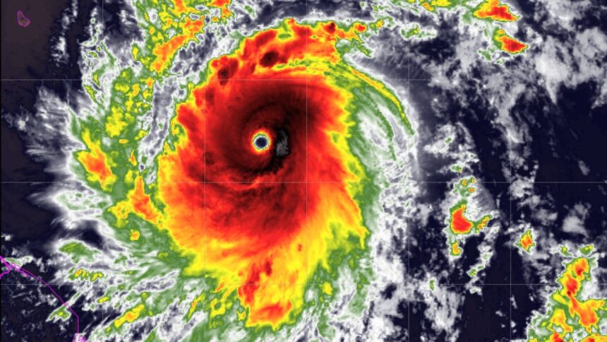
The first Beryl Hurricane of the year 2024 is going to knock in the Caribbean Sea soon. The wind will blow at a high speed at the time of the storm Beryl. Before Hurricane Beryl makes landfall, a warning has been issued. Forecasters say that Beryl will rapidly turn into a very large storm. At the same time, before the arrival of the storm, there is a huge crowd of people at the petrol pump.
storm Beryl: Beryl, 2024 is now the first storm of the Atlantic hurricane season. Sunday saw the issuance of a warning in the Southeast Caribbean area after that. It will intensify quickly into a powerful storm, according to forecasters.
The beryl, which is presently traveling in the Atlantic Ocean around 530 miles (850 kilometers) east of Barbados, is predicted to bring powerful winds and storm surges with it when it makes landfall on the Windward Islands on Monday morning, according to the US National Hurricane Center (NHC).
The NHC warned that the storm would become hazardous by the time it reached Caribbean towns, indicating that it was becoming stronger.
Warning issued about Beryl
Barbados, St Lucia, Saint Vincent and the Grenadines and Grenada are all under storm warning, while tropical storm warning or monitoring is in effect for Martinique, Tobago and Dominica, the NHC said in its latest advisory.
In Bridgetown, the capital of Barbados, cars were backed up at gas stations and rows of people were filling up grocery shops and supermarkets with food, drink, and other necessities. In several homes, the merchandise was already secured.
Large storms that reach a wind speed of at least 111 miles per hour (179 kilometers per hour) are classified as category 3 or higher on the Saffir-Simpson scale.
Within the Atlantic hurricane season, which spans from early June to late November, experts warned that a storm of this magnitude and speed is quite unusual.
U5 hurricanes hit Atlantic before first week of July
Beryl Hurricane expert Michael Lowry said on social networking site X, “Until the first week of July, only five major (Category 3+) hurricanes have been recorded in the Atlantic.” It is anticipated that Beryl will be the first hurricane from the Far East to land in the tropical Atlantic.
Hurricane #Beryl continues to quickly strengthen this Sunday morning. The storm is now a very dangerous category 3 hurricane with maximum sustained winds of 115 mph. Life-threatening winds and storm surge are expected in portions of the Windward Islands by early Monday. Latest at… pic.twitter.com/ELcAT3zaqd
— National Hurricane Center (@NHC_Atlantic) June 30, 2024The NHC said that wind speeds had increased to around 90 mph with maximum sustained gusts at Beryl by 2:00 a.m. (0600 GMT) on Sunday.
It stated that a storm situation is anticipated in the storm warning region starting on Monday AM. As a result of the severe rain, floods, and storm surges, water levels may climb by seven feet (2.1 meters) over average.
Beryl will cause catastrophic damage
The NHC stated that even while Beryl’s eyewall passes across a portion of the Windward Islands, catastrophic air damage is still a potential. It suggested that in certain locations, wind speeds may be 30% greater.
According to the Saffir-Simpson wind scale, winds of at least 74 mph are considered Category 1 hurricanes, while winds of at least 157 mph are considered Category 5 storms.
The US National Oceanic and Atmospheric Administration predicted in late May that this year’s Beryl Hurricane season will be “exceptional,” with seven storms rated as strong as Category 3.
The seasonal phenomena La Niña in the Pacific Ocean and the high Atlantic Ocean temperatures were noted by the NOAA as contributing factors to the projected increase in storm activity.
Climate change has caused meteorological events, such as Beryl Hurricane, to increase in frequency and destructiveness in recent years.


